Pinnacle Geomatics
- For Trimble ™ survey equipment sales and parts contact Geovision
Pinnacle Geomatics
Pinnacle Geomatics provides the best land survey consultancy services Botswana. Whether the service you require from us is BIG or SMALL we will do it! Listed below are some the of services we provide.
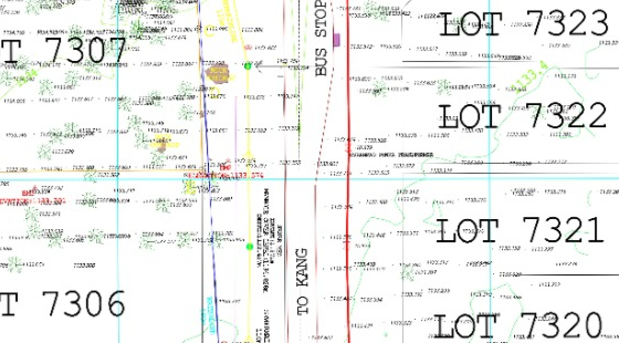
Cadastral surveying is the most common type of land survey used to delineate and define boundaries of land parcels. We have Registered Land Surveyors who assist clients with plot surveying for purposes such as title deed registration, sectional title surveys, beacon relocation, property subdivision and consolidation. Our team ensures that clients can directly lodge their titles with the Deeds Registrar without complications, and we have successfully surveyed thousands of plots across Botswana. Over the years, we have helped hundreds of clients, including the Government of Botswana, and consistently received positive feedback on the quality and efficiency of our work.
Geographical Information Systems (GIS) allow organizations to capture, analyze, present, and share spatial data combined with attribute information in a centralized platform. Our GIS solutions give clients the ability to make informed decisions quickly and with confidence, whether for marketing, operations, or development planning. We create thematic layers tailored to each client’s needs, ensuring that solutions are unique and effective. By enabling access to reliable data from computers or mobile devices, our GIS services enhance competitiveness and streamline workflows across industries.

We utilize the latest drones and advanced payloads/sensors for photogrammetric and LiDAR surveys. Our professional drones allow us to deliver survey-grade datasets quickly and cost-effectively, whether over vast areas with fixed-wing drones or urban sites with copters. Typical deliverables include georeferenced orthophoto mosaics, colorized LiDAR point clouds, Digital Terrain and Surface Models, 3D Building Information Models, volume calculations for stockpiles, and topographic datasets. These products give clients reliable, detailed, and timely insights for their projects.

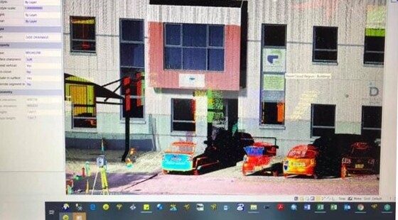
Pinnacle Geomatics has extensive experience in 3D laser scanning of different types of infrastructure including silos, roads, buildings, bridges, mining plants and more. Our end products are tailored to the unique requirements of our clients, and we can adapt to different project scopes with ease. Standard deliverables include georeferenced and colorized high-density point clouds in LAS formats, but our diverse processing platforms also allow us to provide an expanded portfolio of products. This makes our laser scanning solutions flexible, detailed, and highly accurate.
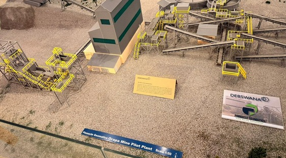
We provide a wide range of mine surveying services and products for both open pit and underground mining. Our expert team works closely with clients to create customized surveying and mapping solutions designed for specific environments and operational needs. We cover all stages of mining, including prospecting, exploitation, and utilization of mineral deposits. By combining modern technologies with industry expertise, we ensure that our solutions enhance safety, efficiency, and accuracy in mining operations.

Our state-of-the-art technologies and software enable us to model built infrastructure and incorporate attribute information that can be shared with stakeholders online. BIM technology is especially valuable for Asset Managers, Architects, Structural Engineers, and other professionals who rely on quality visual data. With BIM, we bring the physical space directly into computers or mobile devices, enabling real-time collaboration, better decision-making, and enhanced project efficiency.
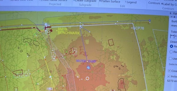
Topographic surveys are conducted to accurately determine ground slopes, contours, and the spatial relationships of natural and man-made features on or beneath the surface. Such surveys are essential before infrastructure and architectural design, as they help define floor levels, drainage, and development plans. We produce high-quality site maps that are easy for clients to interpret without compromising precision. Additionally, we can map buried services to support excavation plans, giving developers the data they need for safe and effective site preparation.
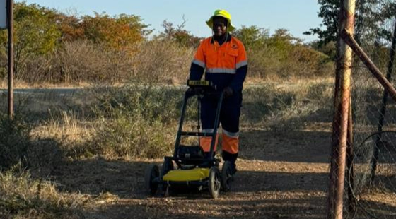
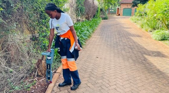
Before excavation, it is critical to know the location and depth of underground services to avoid costly and dangerous accidents. Water lines, electricity, fibre optic cables, and telephone lines are just a few of the buried services that must be identified. Using ground penetrating radar, we accurately determine the position, diameter, depth, and material of underground utilities. This information helps create safe and cost-effective excavation plans while preventing unnecessary repair expenses.
We deploy advanced technologies to measure stockpile or borrow-pit volumes with high accuracy and fast turnaround times. Our deliverables are tailored to suit each client’s needs, whether for mining, construction, or material management. The precision of our solutions allows clients to plan effectively, control costs, and manage resources with confidence.

Our skilled experts specialize in map production, working closely with our spatial data collection team to generate maps of varying scales and detail. The maps we produce are highly customizable, based on client requirements and available data, and are created using state-of-the-art technology. We employ professional drones such as the eBee X RTK, Matrice RTK with Zenmuse sensors, and Phantom Pro RTK to capture spatial information. This enables us to deliver high-quality maps that support planning, monitoring, and decision-making across a range of sectors.